
DESCRIPTION OF THE TRAVERSE
Papua New Guinea, Mt Wilhelm is on the border of Western Highlands, Chimbu and Madang Provinces
The Mt.Wilhelm Traverse starts in the Western Highlands Province of Papua New Guinea, from a small village called Ambullua. Currently the only access to Ambullua is to walk in from either Kol or Kerowagi or helicopter in from Mt.Hagen City. The airstrip is currently closed, but should be opened within the next few months.
The people of Ambullua are subsistance farmers with very few amenities, including no electricity and no running water, but it is at the foot of the famed Mt.Wilhelm (4,509m or 14,793ft). Jack Bal who has lived in Ambullua his whole life decided that he could take advantage of his communities proximity to Mt.Wilhelm and for the last three years has been working tirelessly without pay, between raising a family and farming to build a guest house in Ambullua, as well as a track to the summit.
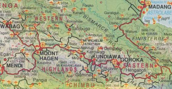
Mt.Wilhelm is near the Centre of the map, Keglsugl is not on the map, but is near Gembogl
At approximately 2000m or 6000ft the walk starts at Jack's guest house (which is closer to the sea than the summit from an altitude perspective). The guest house which is very basic, made out of traditional materials and is quite cozy. It has separate buildings with a pit toilet and a "washing room" although there is neither shower nor bath and water must be carted to wash in. It is above Ambullua mission overlooking the valley and waterfalls and sweet potato gardens. It is surrounded by a small lawn with orchids collected from the forest and plants from the surrounding area.
The first hour of the trek is through sweet potato gardens along a clay path that is in parts very slippery, until you reach the river "Korel" which is crossed via a traditional bridge (ie. a few logs tied together). After crossing the river there are no more gardens and the path follows alongside the river for about half an hour in forest. Starting the ascent of Korel-Khu (the traditional name for Mt. Wilhelm) a moss-forest covered spur is climbed. At times the path is more than a 45 degree angle, but handholds and log steps are on the trail to make the walk slightly easier. After a couple of hours of unrelenting uphill, the path flattens out (relatively flattens out anyway) and more distance is covered until you come to Kosap. Kosap is the first of a series of three huts in the forest area. If one gets off to an early start then Kosap is bipassed and you head to Ongoltungi, the third hut which is about two hours walk furthur on. Ongoltungi is the third and last hut. It is the best built with the second hut only really a sheltered place to sit down and rest. There is no need for a tent on the first night as the huts are shelter enough for the 99% of the time that it rains during the night.
The forest is very wet and would rarely drop below 100% humidity, so expect to sweat a lot. While the forest is wet most is absorbed by the moss and ground so water is fairly scarce walking ontop of the spur. While walking through the forest it is not uncommon to see exotic birds crossing the path or to hear strange bird calls. Seeing marsupials is less common because by nature they are nocturnal, and if seen are fair game to end up in the guides cooking pot.
The end of the forest is a furthur one to two hours from Ongoltungi and is marked by the crossing of a small creek. Here the grassland is entered, which is just as unrelenting in its steepness. Often one asks oneself: "Will this hill ever stop?" This type of grassland is dotted with small bushes all around and the path picks and weaves its way around them, following a tributary of the creek crossed at the end of the forest.
I can't personally say much about the view from this part of the trail because both times I've walked this section it has been in heavy fog with visibility of about 100m/300ft. However after camping the night at Hkelip (which is at the top of this region) and having a clear morning, it is plainly obvious that the view on a good day is spectacular.
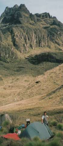
Hkelip is a small saddle with firewood for guides, is reasonably protected from the elements and has fresh water close by. However if you want to push on a little furthur up another incredibly steep hill, there is another saddle half an hour to an hours walk that is much more exposed and a long trip to get any water. Also due to the fact there is no firewood guides cannot stay with you and must make the trip back to Hkelip.
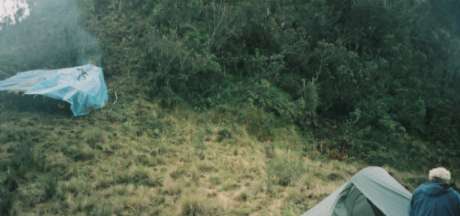
The camp site at Hkelip, the guides hut on the left and my tent on the right
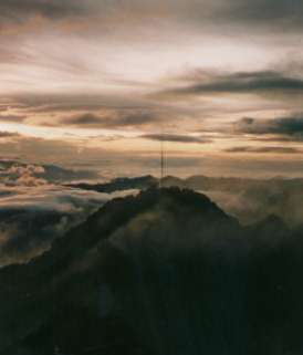
The third day, if it is clear you get magnificent views of surrounding mountins. As you leave Hkelip another steep hill is climbed and then down a couple of minutes into an exposed saddle (which is mentioned as an alternative camp site above). Then again you ascend up a ridge which at its highest is above 4000m. From ontop the summit is viewed for the first time ahead and to the right. It is easy to spot (again assuming the weather is kind) because of the trig marker ontop of it. On neighbouring peaks around the summit one can see abandoned radio transmitters.
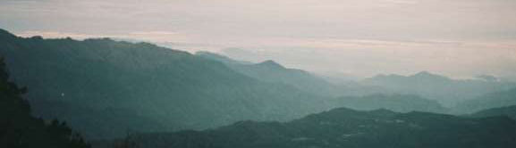
The view from Hkelip looking towards Amubullua
Twice I have been along that ridge, the first it was completely consumed in dense fog and was raining. The second time it started snowing (although only for five minutes and was hardly a big dump). It was a high overcast at the time so the view of the summit was not obscured, but it was indeed not particularly warm. Although this is the tropics and it was about 10am in the morning, the temperature was only about 5 degrees centigrade (about 40 degrees farenheight).
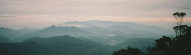
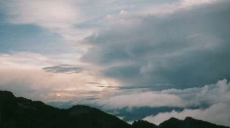
Another spectacular view from Hkelip
One walks along the ridge over its various knolls gradually getting higher, for about two hours. All the while heading towards a large and formiddible stone peak called Werakay. Just before reaching Werakay you go down a saddle and up again skirting around the side of Werakay crossing another ridge that is perpedicular to the one you have been following. Once past this ridge you travel along a Col type formation between Warakay and another peak. On the left is a place called Bungey, about 300m/1000ft below you. Thank your lucky stars because this is where the track used to go, a 300m drop and then another 300m climb. Several hours work for no height gain and very little distance covered. On the right hand side is an unnamed lake that must be 400-500m below the path, and was never known to even Jack himself until he and I investigated this route around Bungy. This shortcut that avoids Bungey is a time saving of about an hour and a half to two hours.
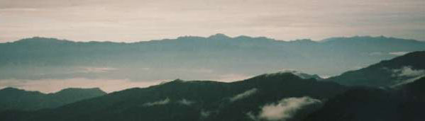
The view from near Hkelip looking towards the Waghi Valley
From the end of the Col formation you go over another ridge that runs perpendicular to the way you've been travelling. Here there is a large valley that runs all the way to the base of the summit. It runs paralell to the ridge that is just crossed, so basically you just hang a right and follow the side of the ridge. The valley is not particularly obvious when you drop over the ridge, as it is obscured by another peak and another saddle. Once you cross this saddle then you drop down a couple of hundred metres into the valley. Again there is a large lake called Korel-Erum. Although one thinks that the path should stick to the top of the ridge as it looks (and indeed does) head straight for the summit, there are two reasons why it doesn't. The first is that the ridge is so jagged and rugged that it is impossible for your average person to follow it. Even if you feel you can, your guides definately won't be able to due to the estremely steep and jagged rock formations that must be crossed. The second reason is that there is still one more camp before reaching the summit and even at the bottom of the valley firewood is scarse, ontop of the ridge it is non-existent.
Near the end of the valley a large rock is reached in an area called Seeku. It is a relatively dry spot, easy to pitch a tent, and the rock provides an overhang for the guides to erect tarp over and sleep under (as there is not more materials for them to build huts up this high). More than half a kilometre above you (and not much furthur infront of you) rises the summit. It is an awesome spectacle.
The view of the summit from Seeku on a particularly good day
Not much height is gained on the third day but a fair amount of distance is. The summit is very tangible and very real. A sense of excitement builds up inside of you, preparing you for the often near verticle climb tomorrow.
If you leave early enough (say 5a.m.) it is possible to be on the summit before 7, which is when the people on the Chimbu side often get to the summit (only they will have left their camp at 2a.m.). Also weather is generally better of a morning so you have a better chance of actually seeing somthing apart from a couple of rocks and a lot of fog!
The first part of the walk is flat and very wet in quagmire conditions. But that changes very quickly, the track steepens. About 3/4 of the way up the grass stops and gives way to very loose and brittle stones. It is very hard going and incredibly steep. You finally reach a little saddle and the border is croseed to the Madang side. Five minutes walk away and another border is crossed over to the Chimbu side. Making your way up to the ridge again where the path on the Chimbu side lies (only about 15 mintues from Western Highlands to Chimbu). When you reach the Chimbu side, the difference is immediately obvious. Rubbish lays around, it is very disappointing. As one joins the main path and makes the final 10 minutes to the summit, you are surrounded by graffiti and more rubbish. When finally stepping on the summit next to the trig marker, you understand though why people would want to come to the Highest place in Papua New Guinea. All around you (if of course you have a good day) are spectacular mountains. You can also pick out the north coast and the sea. The large volcanic Island of Kar Kar near Madang is easily discernible on a good day. The Wahgi valley lays below and a feeling of exhileration overcomes you. Then when your heart rate slows down and you stop puffing, you think "Man that wind is cold". You then take a few happy snaps and get moving again to keep warm.
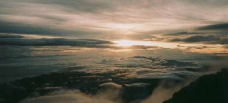
Sunset from near the summit, a large thunder head is on the right side of the picture and provided a spectacular lights show
Here three options are presented: Camp near the summit and explore around it, continue down to Lake Piunde where the two huts that people generally stay in, or for those who can't wait to get off the mountain, and are incrediblly strong (only to be rivalled by superman), the journey all the way down to Keglsugl.
Both photos are taken at sunrise from the summit, left there is an old transmitter on a peak right near the summit
The difference in tracks in noticeable. While towards the upper parts of the Amubllua track, it is virtually non-existant. The Chimbu track is worn away and sometimes resembles a water course. The main summit ridge is followed down through a saddle and past a memorial to a young Australian army officer who went missing in December of 1971. Continuing around a large glaciated valley holding two large lakes joined by a waterfall. Lake Aunde the top lake and Lake Piunde the bottom lake. Past another plaque for a young Israli man who fell off the edge of the path early one morning before the sun came up. Parts of the fuselage of a WW2 B-17 American bomber that was flying too low and smashed into the side of the mountain killing all on board are scattered close to the path. As you decend rapidly the air that seemed fairly thin a couple of days ago now seems hot and stuffy!!
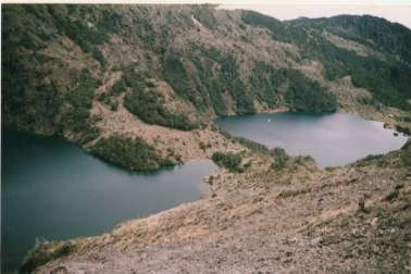
These are the two lakes on the Chimbu side. The one on the Left is Lake Aunde and the one on the right is Piunde. There is about 100ft difference in altitude between them. To give some indication of scale: the small white speck near the edge of the picture on the shores of Piunde is one of the regularly used huts.
Don't get me wrong, the Chimbu side is also spectacular, with a view to the sea for quite a time and the two lakes are beautiful. It is still a very spectacular part of the world to be in!!!
From the huts at Lake Piunde (which will most probably be locked unless the owners or other climbers occupy them - they are rented out by prior arrangement only), a grassy valley flanked by forest covered ridges is descended. At the end you will have your first glimpse of Kelgsugl from a small lookout. From here the graded track is through rainforest the rest of the way to Keglsugl. The best people to go and see is Ken and Betty Higgins, if you've had everything organised they should be expecting you and ready to give you a lift or a bed in their guesthouse for the night. They farm many vegetables, rabbits and trout. (I suggest the strawberries... they are to DIE for).
The drive from Keglsugl to Kundiawa is through the spectacular Chimbu Gorge, which can only be described as amazing and must be seen to be believed!! What once was the sea bed has been tilted to what must be about a 60 degree angle. The river has cut straight through the middle of it. But this is not the most amazing part, what defies all sense of physics is that there are gardens (and gardiners!) clinging to the side of preposterous slope!
Of course you don't have to drive out of Keglsugl because they have an airstrip (and the road really isn't that crash hot anyway). From Kundiawa (the capital of Chimbu province) you would probably go back to Hagen and really want a nice comfy bed to sleep in! From Keglsugl to Hagen is is about 4 hours drive.
So there you have it, the Wilhelm Traverse. Very well worth the effort and a walk to rival the best walks that anywhere has to offer, without the million other people there with you!!
Last Updated: 18/04/2001